
Plaetje:China Hong Kong 4 levels localisation.svg

Aafmaetinge van dees veurbesjoewing van 't type PNG van dit SVG-bestandj: 705 × 599 pixels Anger resoluties: 282 × 240 pixels | 565 × 480 pixels | 904 × 768 pixels | 1.205 × 1.024 pixels | 2.409 × 2.048 pixels | 1.000 × 850 pixels.
Oearsprunkelik bestandj (SVG-bestandj, nominaal 1.000 × 850 pixels, bestandsgruutde: 703 kB)
| Besjrieving |
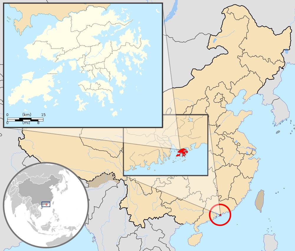
English: Map showing Hong Kong's location in Asia, on China's south coast, and Hong Kong's 18 districts
Français : Carte de Hong Kong : situation en Asie, situation sur le littoral chinois, carte des 18 districts
中文(繁體):顯示香港在亞洲,中國南海岸和香港18區的位置的地圖 |
| Datum | (UTC) |
| Brón |
Deze niet W3C-verklaarde vectorafbeelding is gemaakt met Inkscape . |
| Sjriever |
|
| Anger versies | Derivative works of this file: Hebao island map.jpg |
| Dit is een geretoucheerde foto, wat betekent dat de originele versie digitaal aangepast is. Aanpassingen: Combination, color correction. Het origineel kan hier bekeken worden: China Hong Kong.svg. Aanpassingen gedaan door Pethrus.
|
Dit bestandj steit gelicenseerdj óngere Creative Commons Attribution-Share Alike 3.0 Unported lisensje.
Attribuusje: GFDL
- De maags:
- deile – aafsjrieve, verspreie en dórchgaeve
- hèrminge – 't wèrk aanpasje
- Óngere volgendje veurwaerj:
- Attribuusje – Geer mótj op 'n gepasdje meneer 'n naamsvermeljing make, 'ne link nao de licentie opgaeve, en aangaeve of g'r 't werk verangerd höb. Geer moog dit op eder raejelike meneer doon, meh neet zoea det 't liek ofwen de licentiegaever instump mit eur werk of eur gebroek van zie werk.
- Deil gliek – Went geer dit werk geremix, verangerd of doorverwirk höb, mótj geer 't verangerd matterjaal verspreie ónger dezelfde licentie wie 't oersjprunkelik werk, of 'n licentie die daomit samegeit.
Orzjineel uploadlogbook
This image is a derivative work of the following images:
- File:Hong_Kong_Location.svg licensed with PD-self
- 2008-08-27T13:27:11Z Joowwww 1270x640 (234741 Bytes) a few minor tweaks
- 2008-08-27T13:18:03Z Joowwww 1270x640 (234389 Bytes) new version: more detailed, colours are standard with most other locator maps
- 2008-04-20T13:54:51Z Joowwww 1270x640 (79729 Bytes) reduced height, removed map border and added rivers and hk's maritime border
- 2008-04-09T11:31:22Z Joowwww 1270x977 (66085 Bytes) {{Information |Description=A map showing Hong Kong's location in Asia, in China and on China's south coast. |Source=self-made |Date=2008-04-09 |Author= [[User:Joowwww|Joowwww]] |Permission={{PD-self}} |other_versions= }} {{Cr
- File:Map_of_Hong_Kong_18Districts_ZH.svg licensed with Cc-by-sa-3.0, GFDL
- 2008-07-05T21:14:26Z Moddlyg 1454x1083 (381097 Bytes) == Summary == {{Information |Description={{en|1=Map of Hong Kong & 18 Districts (Chinese Version)}} |Source=Own work by uploader |Author={{User:Moddlyg/Sign}} |Date=2008/7/6 |Permission= |other_versions= }} {{ImageUpload|ful
- 2008-07-05T20:59:35Z Moddlyg 1454x1083 (262750 Bytes) {{Information |Description={{en|1=Map of Hong Kong & 18 Districts (Chinese Version)}} |Source=Own work by uploader |Author=~~~ |Date=2008/7/6 |Permission= |other_versions= }}
- File:China_Hong_Kong.svg licensed with PD-self
- 2008-08-13T16:22:08Z Joowwww 1000x850 (212124 Bytes) added missing laos/vietnam border
- 2008-05-14T11:14:46Z Joowwww 1000x850 (210515 Bytes) {{Information |Description=An SVG map of China with Hong Kong special administrative region highlighted and circled Legend:[[Image:China map legend.png]] |Source=self-made; based on CIA public domain maps: *http://www.lib.ut
Uploaded with derivativeFX
Besjtandshistorie
Klik op 'ne datum/tied óm 't besjtand te zeen wie 't oetzaog op det tiedsjtip.
| Datum/Tied | Miniatuurplaetje | Aafmaetinge | Gebroeker | Kómmentaar | |
|---|---|---|---|---|---|
| hujig | 22 sep 2019 23:33 | | 1.000 × 850 (703 kB) | En rouge | added map scale, for the higher resolution sub-picture |
| 14 mei 2015 09:57 |  | 1.000 × 850 (686 kB) | Flappiefh | Fixed colour of Haïnan. | |
| 5 mrt 2010 20:40 |  | 1.000 × 850 (685 kB) | Pethrus | {{Information |Description={{en|1=Map showing Hong Kong's location in Asia, on China's south coast, and Hong Kong's 18 disctricts}} {{fr|1=Carte de Hong Kong : situation en Asie, situation sur le littoral chinois, carte des 18 disctricts}} |Source=*[[:Fil |
Plaetjesverwiezinge
Dit plaetje weurt op de volgende pazjena's gebroek:
Globaal besjtandjsgebroek
De volgende anger wiki's gebroeke dit bestandj:
- Gebroek in ami.wikipedia.org
- Gebroek in as.wikipedia.org
- Gebroek in azb.wikipedia.org
- Gebroek in bh.wikipedia.org
- Gebroek in bo.wikipedia.org
- Gebroek in br.wikipedia.org
- Gebroek in cbk-zam.wikipedia.org
- Gebroek in dty.wikipedia.org
- Gebroek in dz.wikipedia.org
- Gebroek in en.wikipedia.org
- Gebroek in fi.wikipedia.org
- Gebroek in fr.wikipedia.org
- Gebroek in fr.wikinews.org
- Gebroek in fr.wiktionary.org
- Gebroek in fur.wikipedia.org
- Gebroek in gcr.wikipedia.org
- Gebroek in gn.wikipedia.org
- Gebroek in incubator.wikimedia.org
- Gebroek in io.wikipedia.org
- Gebroek in it.wikipedia.org
- Gebroek in ja.wikipedia.org
- Gebroek in lld.wikipedia.org
- Gebroek in lo.wikipedia.org
- Gebroek in mad.wikipedia.org
- Gebroek in mai.wikipedia.org
Bekiek wikiwied gebroek van dit bestandj.