Naar inhoud springen

Plaetje:Byzantine Constantinople-tr.png

Pagina-inhoud wordt niet ondersteund in andere talen.
Van Wikipedia

Oearsprunkelik bestandj ((3.075 × 2.775 pixel, besjtandsgruutde: 3,08 MB, MIME type: image/png))

Dit besjtandj kump van Wikimedia Commons en kin ouch in anger projekte gebroek waere. De pagina mit de besjtandjsbesjrieving wurt hiejónger weergegaeve.

Wikipedia

 Dit is een uitgelichte afbeelding op de Turkstalige Wikipedia (Seçkin resimler) en wordt beschouwd als een van de beste afbeeldingen.

Als u vindt dat dit bestand ook op Wikimedia Commons een uitgelichte afbeelding zou moeten worden, voelt u zich dan vrij het te nomineren.
Als u een bestand van vergelijkbare kwaliteit heeft dat kan worden gepubliceerd onder een geschikte copyrightlicentie, upload het dan, voeg een licentie toe, en nomineer het.

Besjrieving

Besjrieving
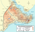
Deutsch: Topografische Karte Konstantinopel (heute Istanbul) während des byzantinischen Zeitraums. Quelle: R. Janin, Constantinople Byzantine. Developpement urbain et repertoire topographique. Straßennetz und andere Einzelheiten basiert auf Dumbarton Oaks Papers 54. Kirchen, insb. nicht identifizierte und ausgegrabene Bauten sind aus dem The Byzantine Churches of Istanbul entnommen. Andere herausgegebenen Quellen wurden behilfsmäßig gebraucht.
English: Topographical map of Constantinople (present day Istanbul) during the Byzantine period. Main map source: R. Janin, Constantinople Byzantine. Developpement urbain et repertoire topographique. Road network and some other details based on Dumbarton Oaks Papers 54; data on many churches, especially unidentified ones, taken from the University of New York's The Byzantine Churches of Istanbul project. Other published maps and accounts of the city have been used for corroboration.
Türkçe: Konstantinopolis (bugün Istanbul)'in topografik haritası. Ana haritanın kaynağı: R. Janin, Constantinople Byzantine. Developpement urbain et repertoire topographique. Yol haritası ve bazı diğer ayrıntıların kaynağı: Dumbarton Oaks Papers 54; kiliseler, özellikle kimliği belirlenmemiş olanlar hakkında veriler, New York University'nin İstanbul'un Bizans Kiliseleri projesinden elde edilmiştir. Şehir hakkında yayımlanmış diğer harita ve metinler bu bilgileri doğrulamak için kullanılmıştır.
Ελληνικά: Τοπογραφικός χάρτης Κωνσταντινουπόλεως (σήμερα είναι Ιστανμπούλ) κατά τη Βυζαντινή περίοδο. Βασική πηγή χάρτη: R. Janin, Constantinople Byzantine. Developpement urbain et repertoire topographique. Το οδικό δίκτυο και διάφορες άλλες λεπτομέρειες με βάση το Dumbarton Oaks Papers 54. Πληροφορίες για μη ταυτοποιημένες εκκλησίες από την ιστοσελίδα The Byzantine Churches of Istanbul του Πανεπιστημίου της Νέας Υόρκης.
Български: Топографска карта на Константинопол (днес Истанбул) през византийския период. Източник: R. Janin, Constantinople Byzantine. Developpement urbain et repertoire topographique. Пътната мрежа и някои други детайли се основават на Dumbarton Oaks Papers 54 и други публикувани източници.
Although I've striven to make this map as complete and correct as possible, there may be some errors or omissions. Any corrections & suggestions are welcome.
Datum (UTC)
Brón
Sjriever
Anger versies

[bewirk]

Full maps

SVG:

PNG:

Numeric versions

Regions

Roads


Dit is een geretoucheerde foto, wat betekent dat de originele versie digitaal aangepast is. Aanpassingen: converted to PNG format. Het origineel kan hier bekeken worden: Byzantine Constantinople-tr.svg. Aanpassingen gedaan door İnfoCan.

Ich, de kopierechhaajer hievan, bring 't hiebie óngere vólgendje lisensje oet:
w:nl:Creative Commons
Attribuusje Deil gliek
Dit bestandj steit gelicenseerdj óngere Creative Commons Attribution-Share Alike 3.0 Unported lisensje.
De maags:
  • deile – aafsjrieve, verspreie en dórchgaeve
  • hèrminge – 't wèrk aanpasje
Óngere volgendje veurwaerj:
  • Attribuusje – Geer mótj op 'n gepasdje meneer 'n naamsvermeljing make, 'ne link nao de licentie opgaeve, en aangaeve of g'r 't werk verangerd höb. Geer moog dit op eder raejelike meneer doon, meh neet zoea det 't liek ofwen de licentiegaever instump mit eur werk of eur gebroek van zie werk.
  • Deil gliek – Went geer dit werk geremix, verangerd of doorverwirk höb, mótj geer 't verangerd matterjaal verspreie ónger dezelfde licentie wie 't oersjprunkelik werk, of 'n licentie die daomit samegeit.
GNU head Toesteumming wert verleend veur t kopiëre, verspreide en/of wiezige van dit document onger de veurwaerd van de GNU-licentie veur vrieje documentatie, versie 1.2 of einige latere versie es gepubliceerd door de Free Software Foundation; zonger Invariant Sections, zonger Front-Cover Texts, en zonger Back-Cover Texts. n kopie van de licentie is opgenomme in de sectie GNU-licentie veur vrieje documentatie.
De kens zelf de lisensje oetkeze.

Orzjineel uploadlogbook

This image is a derivative work of the following images:

  • File:Byzantine_Constantinople_tr.svg licensed with Cc-by-sa-3.0, GFDL
    • 2010-06-28T18:40:55Z InfoCan 2050x1850 (1724813 Bytes) {{Information |Description={{en|1=Topographical map of [[Constantinople]] during the [[Byzantine Empire|Byzantine]] period. Main map source: R. Janin, ''Constantinople Byzantine. Developpement urbain et repertoire topographiq

Uploaded with derivativeFX

Bijschriften

Beschrijf in één regel wat dit bestand voorstelt

Items getoond in dit bestand

beeldt af Nederlands

MIME-type Nederlands

image/png

checksum Nederlands

2a8555295bb94f3d58e3e5f1388153f20ca0f261

methode van vaststelling Nederlands: SHA-1 Nederlands

datagrootte Nederlands

3.228.747 byte

hoogte Nederlands

2.775 pixel

breedte Nederlands

3.075 pixel

Besjtandshistorie

Klik op 'ne datum/tied óm 't besjtand te zeen wie 't oetzaog op det tiedsjtip.

Datum/TiedMiniatuurplaetjeAafmaetingeGebroekerKómmentaar
hujig8 aug 2010 20:53Miniatuurplaetje veur versie per 8 aug 2010 20:533.075 × 2.775 (3,08 MB)İnfoCan{{Information |Description= |Source= |Date= |Author= |Permission= |other_versions= }}
9 jul 2010 01:26Miniatuurplaetje veur versie per 9 jul 2010 01:263.075 × 2.775 (3,08 MB)InfoCan
9 jul 2010 01:24Miniatuurplaetje veur versie per 9 jul 2010 01:243.075 × 2.775 (3,08 MB)InfoCan{{Information |Description= |Source= |Date= |Author= |Permission= |other_versions= }}
9 jul 2010 00:44Miniatuurplaetje veur versie per 9 jul 2010 00:443.075 × 2.775 (3,08 MB)InfoCan{{Information |Description={{en|1=Topographical map of Constantinople during the Byzantine period. Main map source: R. Janin, ''Constantinople Byzantine. Developpement urbain et repertoire topographique''. Road network and some ot

Gein inkel pazjena gebroek dit plaetje.

Globaal besjtandjsgebroek

Aafkomstig van Wikipedia, de Vriej Encyclopedie. "https://li.wikipedia.org/wiki/Plaetje:Byzantine_Constantinople-tr.png"