
Plaetje:Extensió del valencià al País Valencià.svg

Aafmaetinge van dees veurbesjoewing van 't type PNG van dit SVG-bestandj: 424 × 600 pixels Anger resoluties: 170 × 240 pixels | 339 × 480 pixels | 543 × 768 pixels | 724 × 1.024 pixels | 1.448 × 2.048 pixels | 744 × 1.052 pixels.
Oearsprunkelik bestandj (SVG-bestandj, nominaal 744 × 1.052 pixels, bestandsgruutde: 962 kB)
Besjrieving
| Beschrijving |
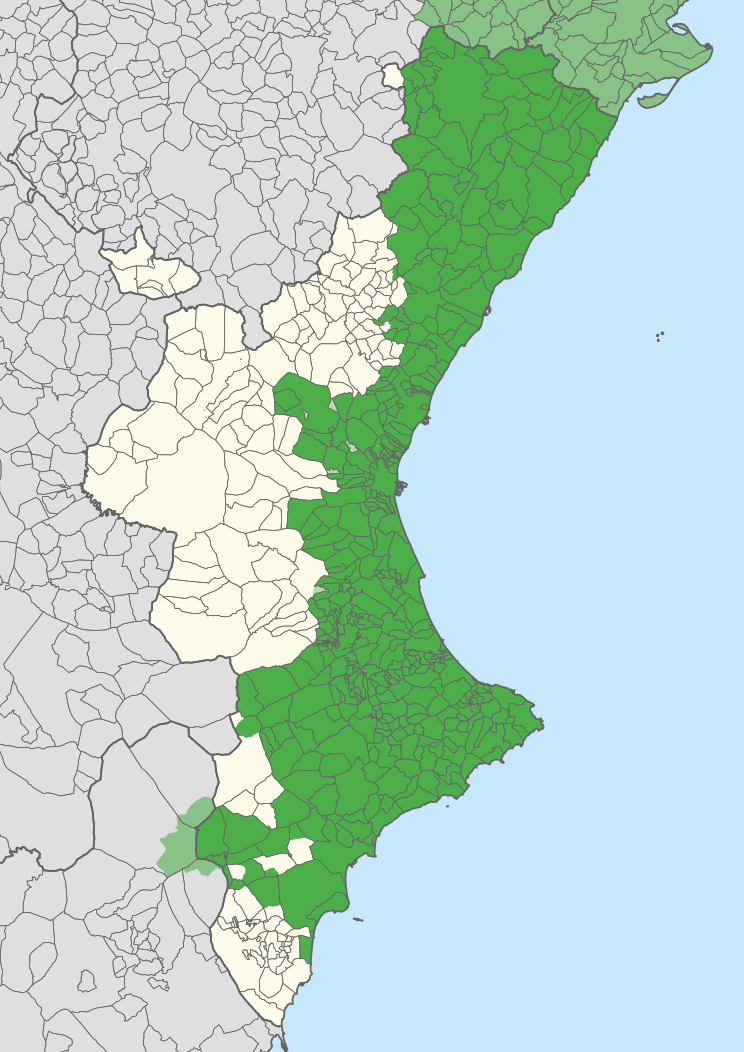
English: Extension of the Valencian language in the Valencian Community, according to Casanova and Sanchis Guarner.
Español: Extensión del Valenciano en la Comunidad Valenciana. |
| Map legend |
Català:
Zones valencianoparlants a la Comunitat Valenciana. Zones valencianoparlants fora de la Comunitat Valenciana. Zones castellanoparlants a la Comunitat Valenciana que eren valencianoparlants el principi del s. XX. English:
Valencian-speaking regions in the Valencian Community. Valencian-speaking regions outside the Valencian Community. Spanish-speaking regions in the Valencian Community that were Valencian-speaking at the beginning of the 20th century. Español: Zonas Valencianoparlantes en la Comunidad Valenciana. Zones Valencianoparlantes fuera de la Comunidad Valenciana. Zonas Castellanoparlantes en la Comunidad Valenciana que eran Valencianoparlantes al principio del siglo XX. |
| Datum | |
| Brón | Carche.map and OpenStreetMap. |
| Maker | |
| Geotemporal data | |
| Schaal | 1:1.500.000 |
| Heading |
 |
| Georeferencing | If inappropriate please set warp_status = skip to hide. |
| Anger versies |
Derivative works of this file: |
| SVG ontwikkeling | De broncode van dit SVG-bestand is deugdelijk. |
Licentie:
| This work contains information from OpenStreetMap, which is made available under the Open Database License (ODbL).
The ODbL does not require any particular license for maps produced from ODbL data. Prior to 1 August 2020, map tiles produced by the OpenStreetMap Foundation were licensed under the CC-BY-SA-2.0 license. Maps produced by other people may be subject to other licences. |
Dit bestandj steit gelicenseerdj óngere Creative Commons Attribution-Share Alike 2.5 Generic lisensje.
Attribuusje: Joan M. Borràs (ebrenc)
- De maags:
- deile – aafsjrieve, verspreie en dórchgaeve
- hèrminge – 't wèrk aanpasje
- Óngere volgendje veurwaerj:
- Attribuusje – Geer mótj op 'n gepasdje meneer 'n naamsvermeljing make, 'ne link nao de licentie opgaeve, en aangaeve of g'r 't werk verangerd höb. Geer moog dit op eder raejelike meneer doon, meh neet zoea det 't liek ofwen de licentiegaever instump mit eur werk of eur gebroek van zie werk.
- Deil gliek – Went geer dit werk geremix, verangerd of doorverwirk höb, mótj geer 't verangerd matterjaal verspreie ónger dezelfde licentie wie 't oersjprunkelik werk, of 'n licentie die daomit samegeit.
Besjtandshistorie
Klik op 'ne datum/tied óm 't besjtand te zeen wie 't oetzaog op det tiedsjtip.
| Datum/Tied | Miniatuurplaetje | Aafmaetinge | Gebroeker | Kómmentaar | |
|---|---|---|---|---|---|
| hujig | 21 apr 2020 13:27 | | 744 × 1.052 (962 kB) | FogueraC | voltants |
| 20 apr 2020 18:24 |  | 744 × 1.052 (881 kB) | FogueraC | standard colors | |
| 18 mei 2007 03:12 |  | 725 × 1.244 (1,53 MB) | Ebrenc | {{Cc-by-sa-2.5|Joan M. Borràs (ebrenc)}} Category:Maps of the Land of Valencia Category:Catalan language |
Plaetjesverwiezinge
Gein inkel pazjena gebroek dit plaetje.
Globaal besjtandjsgebroek
De volgende anger wiki's gebroeke dit bestandj:
- Gebroek in ar.wikipedia.org
- Gebroek in ast.wikipedia.org
- Gebroek in ca.wikipedia.org
- Gebroek in co.wikipedia.org
- Gebroek in cs.wikipedia.org
- Gebroek in de.wikipedia.org
- Gebroek in en.wikipedia.org
- Gebroek in es.wikipedia.org
- Comunidad Valenciana
- Discusión:Idiomas de España
- Vega Baja del Segura
- Predominio lingüístico
- Ley de uso y enseñanza del valenciano
- Portal:Comunidad Valenciana
- Idioma valenciano
- Usuario:Castellónenred/Página de Pruebas/PortalCV/Cultura y Tradiciones
- Portal:Comunidad Valenciana/Cultura y Tradiciones
- Cultura de la Comunidad Valenciana
- Usuario:MetroVal/Valenciano
- Usuario:JuananMJ/Taller
- Gebroek in es.wikivoyage.org
- Gebroek in eu.wikipedia.org
- Gebroek in ext.wikipedia.org
- Gebroek in fi.wikipedia.org
- Gebroek in fr.wikipedia.org
- Gebroek in gl.wikipedia.org
- Gebroek in he.wikipedia.org
- Gebroek in ia.wikipedia.org
- Gebroek in id.wikipedia.org
- Gebroek in ie.wikipedia.org
- Gebroek in it.wikipedia.org
- Gebroek in ja.wikipedia.org
Bekiek wikiwied gebroek van dit bestandj.