
Plaetje:Northern Ireland in the UK and Europe.svg

Aafmaetinge van dees veurbesjoewing van 't type PNG van dit SVG-bestandj: 713 × 600 pixels Anger resoluties: 285 × 240 pixels | 571 × 480 pixels | 913 × 768 pixels | 1.218 × 1.024 pixels | 2.435 × 2.048 pixels | 2.045 × 1.720 pixels.
Oearsprunkelik bestandj (SVG-bestandj, nominaal 2.045 × 1.720 pixels, bestandsgruutde: 7,84 MB)
Besjrieving
| Besjrieving |
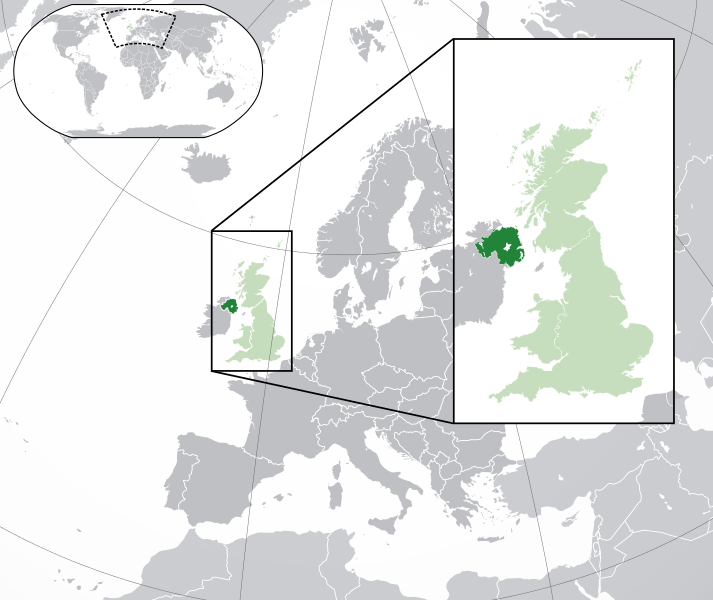
English: A map of Northern Ireland within the United Kingdom and Europe. The map is a polar orthographic projection.
Northern Ireland
Great Britain/United Kingdom except Northern Ireland
Europe (except UK) Français : Une carte de l'Irlande du Nord au sein du Royaume-Uni et en Europe. La carte est un polair projection orthographique.
Irlande du Nord
Grande-Bretagne/Royaume-Unie sauf l'Irlande du Nord
Europe (sauf le Royaume-Unie) Deutsch: Eine Karte der Nordirland drinnen das Vereinigtes Königreich und drinnen Europa. Die Karte ist ein polare orthografische Azimutalprojektion.
Nordirland
Großbritannien/Vereinigtes Königreich außer Nordirland
Europa (außer das Vereinigtes Königreich) Cymraeg:
Gogledd Iwerddon
Y Deyrnas Unedig
Ewrop Gàidhlig:
Èirinn a Tuath
An Rìoghachd Aonaichte
An Roinn-Eòrpa Gaeilge: Tuaisceart Éireann
An Ríocht Aontaithe
An Eoraip |
| Datum | (UTC) |
| Brón |
Dit bestand is afgeleid van: Blank map of Europe (with disputed regions).svg: |
| Sjriever |
|
| Anger versies |
|
| SVG ontwikkeling |


.svg)
Licentie:
Dit bestandj steit gelicenseerdj óngere Creative Commons Attribution-Share Alike 3.0 Unported lisensje.
- De maags:
- deile – aafsjrieve, verspreie en dórchgaeve
- hèrminge – 't wèrk aanpasje
- Óngere volgendje veurwaerj:
- Attribuusje – Geer mótj op 'n gepasdje meneer 'n naamsvermeljing make, 'ne link nao de licentie opgaeve, en aangaeve of g'r 't werk verangerd höb. Geer moog dit op eder raejelike meneer doon, meh neet zoea det 't liek ofwen de licentiegaever instump mit eur werk of eur gebroek van zie werk.
- Deil gliek – Went geer dit werk geremix, verangerd of doorverwirk höb, mótj geer 't verangerd matterjaal verspreie ónger dezelfde licentie wie 't oersjprunkelik werk, of 'n licentie die daomit samegeit.
Orzjineel uploadlogbook
This image is a derivative work of the following images:
- File:Blank_map_of_Europe.svg licensed with Cc-by-sa-2.5
- 2012-02-21T16:27:27Z Alphathon 680x520 (614699 Bytes) Updated Metadata and the boarders/coastlines along the western coast of the Black Sea
- 2011-09-19T22:57:58Z Alphathon 680x520 (603759 Bytes) Added North/Northern Cyprus
- 2011-08-23T10:26:48Z Heb 680x520 (604212 Bytes) Added [[:en:Bornholm]] (taken from [[:File:Denmark blank map.svg]])
- 2011-04-12T00:40:40Z Alphathon 680x520 (602549 Bytes) Upgraded Sicily based on "File:Freeworldmaps-sicily.jpg". Upgraded Malta based on "File:Map of Malta 2.png". Simplified Croatian borders.
- 2011-04-10T21:43:04Z Alphathon 680x520 (607359 Bytes) Upgraded Croatia, Bosnia & Herzegovina, Slovenia and surrounding countries based on data from "File:Kroatien - Politische Gliederung (Karte).png"
- 2011-04-10T20:05:09Z Alphathon 680x520 (568373 Bytes) Improved Serbia, Montenegro and surrounding countries using data from "File:Serbia Map.png". Fixed Serbia-Montenegro border. Added Kosovo (using dashed border, since it is not a universally recognised nation, and left the lan
- 2011-04-10T15:55:02Z Alphathon 680x520 (524980 Bytes) Tweaked Ukraine and surrounding countries based on data from "File:Up-map.png"
- 2011-04-10T04:02:09Z Alphathon 680x520 (511168 Bytes) Improved Greece, Albania, F.Y.R. Macedonia and Bulgaria based on "File:Greece topo.jpg"
- 2011-04-10T02:48:52Z Alphathon 680x520 (505569 Bytes) Tweaked Germany and surrounding countries based on info from "File:Germany_general_map.png"
- 2011-04-10T01:54:05Z Alphathon 680x520 (493733 Bytes) Converted all lakes back to separate layer. Added Finish lakes and tweaked Finland shape based on "File:Finland 1996 CIA map.jpg". Added Swiss lakes based on "File:Suisse cantons.svg". Tweaked Scotland and added Lochs.
- 2011-04-10T00:07:54Z Alphathon 680x520 (450120 Bytes) Improved England outline and added Isle of Wight based on "File:England Regions - Blank.svg". Improved Denmark based on "File:2 digit postcode danmark.png". Improved Sweden based on "File:Map of Sweden, CIA, 1996.jpg"
- 2011-04-08T15:53:07Z Alphathon 680x520 (438878 Bytes) Upgraded/fixed various parts of the map. Details: *Some minor fixes to Ireland and added some of the larger lakes based on [[:File:Ireland_trad_counties_named.svg]] *Pretty major fixes to Scotland (mainly the west coast and i
- 2008-09-17T09:50:25Z F7 680x520 (531491 Bytes)
- 2008-09-17T09:42:57Z F7 680x520 (2353 Bytes)
- 2008-05-26T19:04:07Z Collard 680x520 (531491 Bytes) uploading on behalf of [[User:Checkit]], direct complaints to him plox: 'Moved countries out of the "outlines" group, removed "outlines" style class, remove separate style information for Russia'
- 2008-04-30T01:38:52Z TimothyBourke 680x520 (531767 Bytes) Changed the country code of Serbia to RS per [http://en.wikipedia.org/wiki/Serbian_country_codes] and the file [http://www.iso.org/iso/iso3166_en_code_lists.txt].
- 2008-02-08T22:44:37Z CarolSpears 680x520 (531767 Bytes) validated
- 2007-07-10T11:47:59Z MrWeeble 680x520 (533112 Bytes) Updated to include British Crown Dependencies as seperate entities and regroup them as "British Islands", with some simplifications to the XML and CSS
- 2007-05-14T17:17:34Z Zirland 680x520 (540659 Bytes) serbia and montenegro
- 2007-03-30T20:40:49Z W!B: 680x520 (538830 Bytes) minor corr: update nl:Ijsselmeer, del fi:lakes (all small), add ru:lake Oneka (all ref maps.google), glued northern irland back to ie ;)
- 2007-02-05T18:44:32Z Maix 680x520 (538295 Bytes) cropped
- 2007-02-04T15:07:29Z Maix 680x520 (538310 Bytes) {{Information |Description=A blank Map of Europe in SVG format. Every country has an id which is its ISO-3116-1-ALPHA2 code in lower case for easy coloring. |Source=Image based on [[Image:Europe_countries.svg|]] by [[User:Ti
Uploaded with derivativeFX
Besjtandshistorie
Klik op 'ne datum/tied óm 't besjtand te zeen wie 't oetzaog op det tiedsjtip.
| Datum/Tied | Miniatuurplaetje | Aafmaetinge | Gebroeker | Kómmentaar | |
|---|---|---|---|---|---|
| hujig | 6 aug 2014 22:00 | | 2.045 × 1.720 (7,84 MB) | Rob984 | Improved version: More accurate coastline, borders, etc. Added Gradient and Longitude and latitude lines. Zoom insert centred on UK. |
| 21 fib 2014 16:57 |  | 680 × 520 (2,48 MB) | Rob984 | White background so that the edge of the map is clear. Consistency with other European countries' maps also. | |
| 19 jan 2013 20:24 |  | 680 × 520 (2,46 MB) | Alphathon | Added Robinson projection to top left corner. | |
| 27 fib 2012 01:38 |  | 680 × 520 (941 kB) | Alphathon | Fixed XML | |
| 27 fib 2012 01:34 |  | 680 × 520 (941 kB) | Alphathon | More detailed version of the British Isles | |
| 26 fib 2012 02:36 |  | 680 × 520 (789 kB) | Alphathon | Added missing parts of Belgium and the Netherlands. | |
| 26 fib 2012 00:36 |  | 680 × 520 (806 kB) | Alphathon | == {{int:filedesc}} == {{Information |Description={{en|A map of Northern Ireland (dark green) within the United Kingdom (dark and light green) and Europe (dark green, light green and darker grey).}} |Source={{Derived from|Blank_map_of_Europe.svg|displa... |
Plaetjesverwiezinge
Dit plaetje weurt op de volgende pazjena's gebroek:
Globaal besjtandjsgebroek
De volgende anger wiki's gebroeke dit bestandj:
- Gebroek in af.wikipedia.org
- Gebroek in af.wiktionary.org
- Gebroek in am.wikipedia.org
- Gebroek in ang.wikipedia.org
- Gebroek in ar.wikipedia.org
- Gebroek in arz.wikipedia.org
- Gebroek in az.wikipedia.org
- Gebroek in be-tarask.wikipedia.org
- Gebroek in be.wikipedia.org
- Gebroek in bg.wikipedia.org
- Gebroek in bh.wikipedia.org
- Gebroek in blk.wikipedia.org
- Gebroek in bn.wikipedia.org
- Gebroek in bs.wikipedia.org
- Gebroek in bxr.wikipedia.org
- Gebroek in ca.wikipedia.org
- Gebroek in cdo.wikipedia.org
- Gebroek in chy.wikipedia.org
- Gebroek in diq.wikipedia.org
- Gebroek in el.wikipedia.org
- Gebroek in en.wikipedia.org
- Gebroek in en.wikinews.org
- Gebroek in eo.wikipedia.org
- Gebroek in es.wikipedia.org
- Gebroek in et.wikipedia.org
- Gebroek in fa.wikipedia.org
- Gebroek in fa.wikivoyage.org
- Gebroek in fi.wikipedia.org
- Gebroek in fr.wikipedia.org
- Gebroek in fr.wikinews.org
Bekiek wikiwied gebroek van dit bestandj.