
Plaetje:MapWaregem.svg

Aafmaetinge van dees veurbesjoewing van 't type PNG van dit SVG-bestandj: 800 × 571 pixels Anger resoluties: 320 × 228 pixels | 640 × 457 pixels | 1.024 × 731 pixels | 1.280 × 913 pixels | 2.560 × 1.826 pixels | 1.277 × 911 pixels.
Oearsprunkelik bestandj (SVG-bestandj, nominaal 1.277 × 911 pixels, bestandsgruutde: 118 kB)
Besjrieving
| Besjrieving |
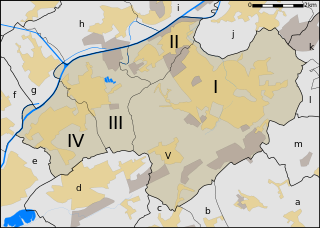
Map of Waregem, West-Flanders, Belgium, neighbourhoods within the municipality and its neighbours.
Neighbouring villages and cities:
|
| Datum | |
| Brón | Eige werk |
| Sjriever | User:LimoWreck |
Licentie:
Ich, de kopierechhaajer hievan, bring 't hiebie óngere vólgendje lisensje oet:

|
Toesteumming wert verleend veur t kopiëre, verspreide en/of wiezige van dit document onger de veurwaerd van de GNU-licentie veur vrieje documentatie, versie 1.2 of einige latere versie es gepubliceerd door de Free Software Foundation; zonger Invariant Sections, zonger Front-Cover Texts, en zonger Back-Cover Texts. n kopie van de licentie is opgenomme in de sectie GNU-licentie veur vrieje documentatie. |
Dit bestandj steit gelicenseerdj óngere Creative Commons Attribution-Share Alike 3.0 Unported lisensje.
- De maags:
- deile – aafsjrieve, verspreie en dórchgaeve
- hèrminge – 't wèrk aanpasje
- Óngere volgendje veurwaerj:
- Attribuusje – Geer mótj op 'n gepasdje meneer 'n naamsvermeljing make, 'ne link nao de licentie opgaeve, en aangaeve of g'r 't werk verangerd höb. Geer moog dit op eder raejelike meneer doon, meh neet zoea det 't liek ofwen de licentiegaever instump mit eur werk of eur gebroek van zie werk.
- Deil gliek – Went geer dit werk geremix, verangerd of doorverwirk höb, mótj geer 't verangerd matterjaal verspreie ónger dezelfde licentie wie 't oersjprunkelik werk, of 'n licentie die daomit samegeit.
De kens zelf de lisensje oetkeze.
Besjtandshistorie
Klik op 'ne datum/tied óm 't besjtand te zeen wie 't oetzaog op det tiedsjtip.
| Datum/Tied | Miniatuurplaetje | Aafmaetinge | Gebroeker | Kómmentaar | |
|---|---|---|---|---|---|
| hujig | 29 aug 2007 23:47 | | 1.277 × 911 (118 kB) | LimoWreck | {{Information |Description=Map of Waregem, West-Flanders, Belgium, neighbourhoods within the municipality and its neighbours. <br/> Waregem: *I. Waregem *II. Sint-Eloois-Vijve *III. Desselgem *IV. Beveren *(V.) Nieuwenhove Neighbouring villages and citie |
Plaetjesverwiezinge
Dit plaetje weurt op de volgende pazjena's gebroek:
Globaal besjtandjsgebroek
De volgende anger wiki's gebroeke dit bestandj: