
Plaetje:US Virgin Islands admin divisions.png
Gruutde van dees veurvertuining: 800 × 486 pixels. Anger resoluties: 320 × 194 pixels | 640 × 389 pixels | 1.022 × 621 pixels.
Oearsprunkelik bestandj ((1.022 × 621 pixel, besjtandsgruutde: 33 kB, MIME type: image/png))

|
This map has been uploaded by Electionworld from en.wikipedia.org to enable the |
Besjrieving
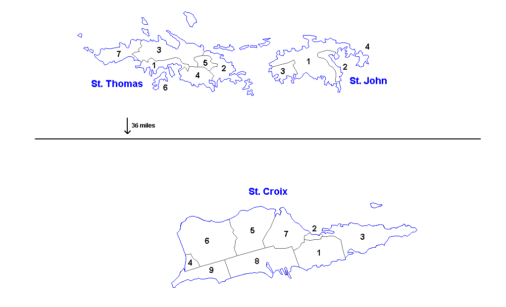
Administrative divisions of the U.S. Virgin Islands. Created by Rarelibra 16:11, 31 March 2006 (UTC) for public domain use. Created using MapInfo Professional v7.5 and vairous mapping resources.
| Districts | Saint Thomas | Saint John | Saint Croix |
|---|---|---|---|
| Sub-districts |
|
|
|
Licentie:
| Iech, de autäörsrechhöbbende vaan dit wirk, geef dit wirk vrij in 't publiek domein. Dit is wereldwijd vaan toupassing. In sommig len is dit wettelik neet meugelek; in die gevalle gelt: Ich staon ederein toe dit wirk veur ènnig doel te broeke, zónger ènnig veurwaerj, behauve zölk veurwaerj dóre wet waere veurgesjreve. |
Besjtandshistorie
Klik op 'ne datum/tied óm 't besjtand te zeen wie 't oetzaog op det tiedsjtip.
| Datum/Tied | Miniatuurplaetje | Aafmaetinge | Gebroeker | Kómmentaar | |
|---|---|---|---|---|---|
| hujig | 19 mrt 2014 15:57 | | 1.022 × 621 (33 kB) | Ahnoneemoos | removing border |
| 19 mrt 2014 15:55 |  | 1.022 × 621 (33 kB) | Ahnoneemoos | removing border | |
| 27 nov 2006 22:31 |  | 1.025 × 624 (15 kB) | Electionworld | {{ew|en|Rarelibra}} == Summary == Administrative divisions (districts and sub-districts) of the U.S. Virgin Islands. Created by Rarelibra 16:11, 31 March 2006 (UTC) for public domain use. Created using MapInfo Professional v7.5 and |
Plaetjesverwiezinge
Dit plaetje weurt op de volgende pazjena's gebroek:
Globaal besjtandjsgebroek
De volgende anger wiki's gebroeke dit bestandj:
- Gebroek in ast.wikipedia.org
- Gebroek in en.wikipedia.org
- Gebroek in eu.wikipedia.org
- Gebroek in gl.wikipedia.org
- Gebroek in mk.wikipedia.org
- Gebroek in ml.wikipedia.org
- Gebroek in nn.wikipedia.org
- Gebroek in no.wikipedia.org
- Gebroek in os.wikipedia.org
- Gebroek in sr.wikipedia.org
- Gebroek in ta.wikipedia.org
- Gebroek in uk.wikipedia.org
- Gebroek in vi.wikipedia.org
- Gebroek in www.wikidata.org