
Plaetje:Odoacer 480ad.jpg

Oearsprunkelik bestandj ((900 × 545 pixel, besjtandsgruutde: 701 kB, MIME type: image/jpeg))

|
Deze kaartafbeelding zou opnieuw moeten worden aangemaakt als een SVG-bestand door vectorafbeeldingen te gebruiken. Dit heeft een aantal voordelen; zie Commons:Media for cleanup voor meer informatie. Als er een SVG-formaat van deze afbeelding bestaat, dan deze graag uploaden. Nadat u dit heeft gedaan, gelieve dit sjabloon te vervangen door het sjabloon {{vector version available|nieuwe bestandsnaam.svg}} op deze afbeeldingspagina.
|


Besjrieving
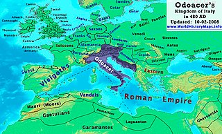
| Besjrieving | Odoacer's Kingdom of Italy in 480 AD. |
| Datum | |
| Brón | Eige werk |
| Sjriever | Thomas Lessman (Contact!) |
| Permissie (Hergebroek van dit besjtandj) |
Ich, de copyrighthauwer van dit wirk, maak 't hiebie ónger óngerstaonde licentie besjikbaar: Dit bestandj steit gelicenseerdj óngere Creative Commons Attribution-Share Alike 3.0 Unported lisensje.
|
| Anger versies | See Below |
Map Summary
Original Source URL: http://www.thomaslessman.com/History/images/East-Hem_480ad.jpg or www.WorldHistoryMaps.info
This map of the Kingdom of Odoacer in 480 AD is a zoomed-in version of Thomas Lessman's map of the East-Hem 480 AD, also available at www.WorldHistoryMaps.info.
The highlighted areas represent Odoacer's Kingdom of Italy, after the capture of Italy (476), conquest of Sicily from the Vandals (477) and the annexation of Dalmatia after the assassination of Emperor Julius Nepos (480).
Map Source References
Remember, sources often conflict with each other. This map is only as accurate as the information that is available to me. To report any errors or to help further this work, please click here, or email Thomas Lessman at talessman@yis.us
References for information contained in this map:
Other Maps by Thomas Lessman
| Maps of the eastern hemisphere showing history
Bold dates are available on Wikimedia or Wikipedia. | ||
| Primeval | ||
| Ancient
|
·| 600 BC | 550 BC | 527 BC | 500 BC |
400 BC | ·| 1 AD | 50 AD | 100 AD | 200 AD | 300 AD | | |
| Medieval |
·| 500 AD | 565 AD | 600 AD | 700 AD | | |
| Modern |
·| 1500 AD | · * For historical maps of the whole world, | |
Besjtandshistorie
Klik op 'ne datum/tied óm 't besjtand te zeen wie 't oetzaog op det tiedsjtip.
| Datum/Tied | Miniatuurplaetje | Aafmaetinge | Gebroeker | Kómmentaar | |
|---|---|---|---|---|---|
| hujig | 23 okt 2022 21:50 | | 900 × 545 (701 kB) | Gyalu22 | Reverted bad faith edit. The Westermanns Atlas doesn't show the Carpi |
| 15 sep 2015 18:05 |  | 900 × 545 (727 kB) | Spiridon Ion Cepleanu | Details about the low-Danube according with H.E.Stier's (dir.) Grosser Atlas zur Weltgeschichte, Westermann 1985. | |
| 2 okt 2008 23:40 |  | 900 × 545 (701 kB) | Talessman | {{Information |Description= |Source= |Date= |Author= |Permission= |other_versions= }} | |
| 10 mei 2008 12:29 |  | 1.402 × 1.023 (380 kB) | Talessman | {{Information |Description=<big>'''The Odoacer's Kingdom of Italy in 477 AD.'''</big> |Source=Self-made |Author=Thomas Lessman |Permission={{self|cc-by-sa-3.0}} }} |
Plaetjesverwiezinge
Dit plaetje weurt op de volgende pazjena's gebroek:
Globaal besjtandjsgebroek
De volgende anger wiki's gebroeke dit bestandj:
- Gebroek in azb.wikipedia.org
- Gebroek in ba.wikipedia.org
- Gebroek in bg.wikipedia.org
- Gebroek in br.wikipedia.org
- Gebroek in ca.wikipedia.org
- Gebroek in de.wikipedia.org
- Gebroek in el.wikipedia.org
- Gebroek in en.wikipedia.org
- Gebroek in es.wikipedia.org
- Gebroek in eu.wikipedia.org
- Gebroek in fi.wikipedia.org
- Gebroek in fr.wikipedia.org
- Gebroek in fy.wikipedia.org
- Gebroek in hy.wikipedia.org
- Gebroek in ia.wikipedia.org
- Gebroek in it.wikipedia.org
- Gebroek in ja.wikipedia.org
- Gebroek in ko.wikipedia.org
- Gebroek in lmo.wikipedia.org
- Gebroek in lt.wikipedia.org
- Gebroek in lv.wikipedia.org
- Gebroek in nds.wikipedia.org
- Gebroek in nl.wikipedia.org
- Gebroek in pl.wikipedia.org
Bekiek wikiwied gebroek van dit bestandj.