
Plaetje:North Korea Topography.png

Gruutde van dees veurvertuining: 583 × 599 pixels. Anger resoluties: 233 × 240 pixels | 467 × 480 pixels | 747 × 768 pixels | 996 × 1.024 pixels | 1.705 × 1.753 pixels.
Oearsprunkelik bestandj ((1.705 × 1.753 pixel, besjtandsgruutde: 3,56 MB, MIME type: image/png))
Besjrieving
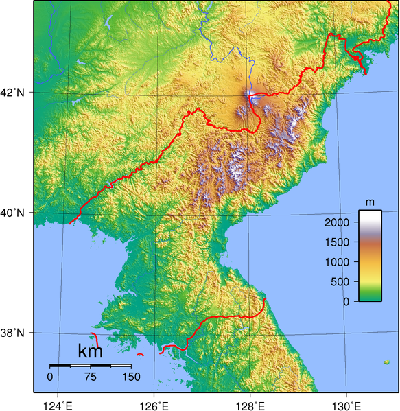
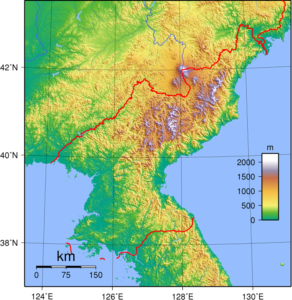
| Besjrieving | Topographic map of the territory claimed by North Korea. Created with GMT from SRTM data. |
| Datum | |
| Brón | Eige werk |
| Sjriever | Sadalmelik |
| Anger versies | Afgeleide werken van dit bestand: Chilbo-san North Korea.jpg |
Licentie:
Ich, de kopierechhaajer hievan, bring 't hiebie óngere vólgendje lisensje oet:

|
Toesteumming wert verleend veur t kopiëre, verspreide en/of wiezige van dit document onger de veurwaerd van de GNU-licentie veur vrieje documentatie, versie 1.2 of einige latere versie es gepubliceerd door de Free Software Foundation; zonger Invariant Sections, zonger Front-Cover Texts, en zonger Back-Cover Texts. n kopie van de licentie is opgenomme in de sectie GNU-licentie veur vrieje documentatie. |
Dit bestandj steit gelicenseerdj óngere Creative Commons Attribution-Share Alike 3.0 Unported, 2.5 Generic, 2.0 Generic enne 1.0 Generic lisensje.
- De maags:
- deile – aafsjrieve, verspreie en dórchgaeve
- hèrminge – 't wèrk aanpasje
- Óngere volgendje veurwaerj:
- Attribuusje – Geer mótj op 'n gepasdje meneer 'n naamsvermeljing make, 'ne link nao de licentie opgaeve, en aangaeve of g'r 't werk verangerd höb. Geer moog dit op eder raejelike meneer doon, meh neet zoea det 't liek ofwen de licentiegaever instump mit eur werk of eur gebroek van zie werk.
- Deil gliek – Went geer dit werk geremix, verangerd of doorverwirk höb, mótj geer 't verangerd matterjaal verspreie ónger dezelfde licentie wie 't oersjprunkelik werk, of 'n licentie die daomit samegeit.
De kens zelf de lisensje oetkeze.
흐화ㅐ ㅜㅜ 할45분
Besjtandshistorie
Klik op 'ne datum/tied óm 't besjtand te zeen wie 't oetzaog op det tiedsjtip.
| Datum/Tied | Miniatuurplaetje | Aafmaetinge | Gebroeker | Kómmentaar | |
|---|---|---|---|---|---|
| hujig | 1 sep 2007 19:48 | | 1.705 × 1.753 (3,56 MB) | Sadalmelik | {{Information |Description=Topographic map of North Korea. Created wth GMT from SRTM data. |Source=self-made |Date=Sep 1, 2007 |Author= Sadalmelik }} Category:Topographic maps of Asia Category:Maps of North Korea |
Plaetjesverwiezinge
Dit plaetje weurt op de volgende pazjena's gebroek:
Globaal besjtandjsgebroek
De volgende anger wiki's gebroeke dit bestandj:
- Gebroek in ang.wikipedia.org
- Gebroek in ar.wikipedia.org
- Gebroek in ast.wikipedia.org
- Gebroek in bbc.wikipedia.org
- Gebroek in be.wikipedia.org
- Gebroek in bg.wikipedia.org
- Gebroek in bn.wikipedia.org
- Gebroek in cy.wikipedia.org
- Gebroek in el.wikipedia.org
- Gebroek in en.wikipedia.org
- Gebroek in es.wikipedia.org
- Gebroek in eu.wikipedia.org
- Gebroek in fi.wikipedia.org
- Gebroek in fi.wikibooks.org
- Gebroek in fr.wikipedia.org
- Gebroek in ha.wikipedia.org
- Gebroek in he.wikipedia.org
- Gebroek in hr.wikipedia.org
- Gebroek in hu.wikipedia.org
- Gebroek in id.wikipedia.org
- Gebroek in it.wikipedia.org
- Gebroek in ja.wikipedia.org
- Gebroek in km.wikipedia.org
- Gebroek in kn.wikipedia.org
- Gebroek in ko.wikipedia.org
- Gebroek in mai.wikipedia.org
- Gebroek in mk.wikipedia.org
- Gebroek in mn.wikipedia.org
- Gebroek in ms.wikipedia.org
- Gebroek in mt.wikipedia.org
- Gebroek in no.wikipedia.org
- Gebroek in pl.wikipedia.org
- Gebroek in pt.wikipedia.org
- Gebroek in ru.wikipedia.org
Bekiek wikiwied gebroek van dit bestandj.