Plaetje:Europe map 1648.PNG
Pagina-inhoud wordt niet ondersteund in andere talen.
Van Wikipedia

Oearsprunkelik bestandj((1.894 × 1.367 pixel, besjtandsgruutde: 195 kB, MIME type: image/png))

Dit besjtandj kump van Wikimedia Commons en kin ouch in anger projekte gebroek waere. De pagina mit de besjtandjsbesjrieving wurt hiejónger weergegaeve.

Deze kaartafbeelding zou opnieuw moeten worden aangemaakt als een SVG-bestand door vectorafbeeldingen te gebruiken. Dit heeft een aantal voordelen; zie Commons:Media for cleanup voor meer informatie. Als er een SVG-formaat van deze afbeelding bestaat, dan deze graag uploaden. Nadat u dit heeft gedaan, gelieve dit sjabloon te vervangen door het sjabloon {{vector version available|nieuwe bestandsnaam.svg}} op deze afbeeldingspagina.

Besjrieving

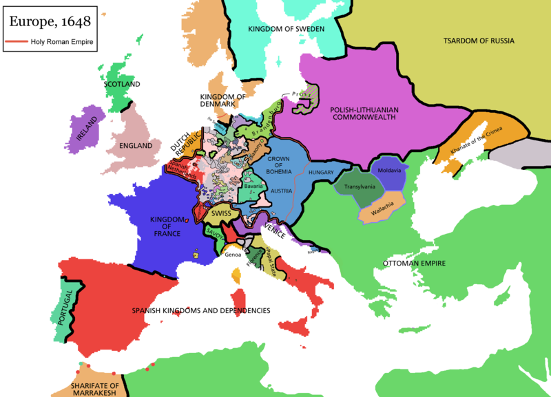
Map of Europe in 1648 (at the end of the Thirty Years War), based on free map of europe Image:BlankMap-Europe.png. Red line marks the border of the Holy Roman Empire. Information from Penguin atlas of modern history. (what year?)

Kaarten van de geschiedenis van Europa
BCE
aC

Weichselian ice age (c. 113,000–9700) · Neolithic expansion (c. 7000–4500) · Middle Neolithic (c. 4500–4000) · Late Neolithic (c. 4000–3000) · Copper Age – Corded Ware culture (c. 2900–2350) · Copper Age – Bellbeaker culture (c. 2800–1800) · Early Bronze Age – Unetice culture (c. 2300–1600) · Late Bronze Age – Urnfield culture (c. 1300—750) · Migrations (c. 1000–100) · Hallstatt & La Tène cultures (c. 800–100) · Roman Republic (510–40) · 220 · 218 · 200 · 201–100 · 58 · 49 · 39 · 30 BCE–6 CE


CE
dC

14 · 14–37 · 60 · 60 · 69 · 80 · Migrations 100–500 · 117 · 117 · 125 · Migrations 150–774 · Economy 180 · 271 · 293–305 · 337 · 395 · c. 395 · 400 · 400 · 450 · 457–61 · 476 · 480 · Franks 481–814 · Early Slavs 500–700 · 500 · 526 · 526–600 · Christianisation to 600 · c. 550 · 650 · Pontic Steppe 650 · 665 · 800 · Vikings 800–1050 · 814 · 843–70 · 850 · 900 · 912 · 998 · 1000 · 1000 · 1054 · 1092 · First Crusade 1095–99 · 1097 · 1135 · 1142 · 1147–49 · 1190 · 1190 · 1250 · c. 1250 · 1301-1400 · 1301-1400 · 1328 · 1345 · Black Plague 1347–51 · 1360 · 1400 · Trade routes c. 1400 · 1430 · 1470 · 1490 · 1492 · 1500 · 1519 · 1550 · 1560 · Religion 1560 · Religion 1600 · Religion 1618 · 1618–48 · 1648 · 1683 · 1700 · 1701 · 1708 · 1714 · 1721 · 1725–30 · 1739–1740 · 1740 · 1748–66 · 1783–1792 · 1787 · 1787 · 1789 · 1799 · 1812 · 1812 · 1812 · 1812 · 1813 · 1815 · 1815 · 1815 · 1818 · Ottoman Empire 1830–1923 · 1848–49 · 1861 · 1867 · 1871 · 1878 · 1890 · 1905 · 1911 · 1914 · 1914 · 1919 · 1919–29 · 1923 · 1929 · 1930 · 1940 · 1941–42 · 1942–45 · Cold War 1947–91 · 1950 · 1993–2006 · 2006 to date

(this template: · view · discuss )


Licentie:

GNU head Toesteumming wert verleend veur t kopiëre, verspreide en/of wiezige van dit document onger de veurwaerd van de GNU-licentie veur vrieje documentatie, versie 1.2 of einige latere versie es gepubliceerd door de Free Software Foundation; zonger Invariant Sections, zonger Front-Cover Texts, en zonger Back-Cover Texts. n kopie van de licentie is opgenomme in de sectie GNU-licentie veur vrieje documentatie.
w:nl:Creative Commons
Attribuusje Deil gliek
Dit bestandj steit gelicenseerdj óngere Creative Commons Attribution-Share Alike 3.0 Unported lisensje.
De maags:
  • deile – aafsjrieve, verspreie en dórchgaeve
  • hèrminge – 't wèrk aanpasje
Óngere volgendje veurwaerj:
  • Attribuusje – Geer mótj op 'n gepasdje meneer 'n naamsvermeljing make, 'ne link nao de licentie opgaeve, en aangaeve of g'r 't werk verangerd höb. Geer moog dit op eder raejelike meneer doon, meh neet zoea det 't liek ofwen de licentiegaever instump mit eur werk of eur gebroek van zie werk.
  • Deil gliek – Went geer dit werk geremix, verangerd of doorverwirk höb, mótj geer 't verangerd matterjaal verspreie ónger dezelfde licentie wie 't oersjprunkelik werk, of 'n licentie die daomit samegeit.
Dees licentie-tag woort tougevoeg aon dit bestand in verband mèt de GFDL licentie-update.

derivative works

Afgeleide werken van dit bestand:

Bijschriften

Beschrijf in één regel wat dit bestand voorstelt

Items getoond in dit bestand

beeldt af Nederlands

MIME-type Nederlands

image/png

Besjtandshistorie

Klik op 'ne datum/tied óm 't besjtand te zeen wie 't oetzaog op det tiedsjtip.

(nuujste | aadste) (nujer 10) () (10 | 20 | 50 | 100 | 250 | 500) bekieke.
Datum/TiedMiniatuurplaetjeAafmaetingeGebroekerKómmentaar
hujig14 apr 2021 11:44Miniatuurplaetje veur versie per 14 apr 2021 11:441.894 × 1.367 (195 kB)TenanReverted to version as of 16:09, 12 October 2017 (UTC) See discussion
9 mrt 2021 12:47Miniatuurplaetje veur versie per 9 mrt 2021 12:471.894 × 1.367 (210 kB)TTBCamhReverted to version as of 17:18, 20 September 2018 (UTC). I don't know why Raderich is saying this is an arbitrary change—Catalonia was under the possession of the French king in 1648, following the Catalan Revolt of 1640. This map is correct and the previous one is incorrect.
25 sep 2018 14:12Miniatuurplaetje veur versie per 25 sep 2018 14:121.894 × 1.367 (195 kB)RaderichReverted to version as of 21:15, 18 September 2018 (UTC) Undone arbitrary changes. Revert to correct map as uploaded by its creator Roke~commonswiki
20 sep 2018 19:18Miniatuurplaetje veur versie per 20 sep 2018 19:181.894 × 1.367 (210 kB)AmbroiseLThe Catalan counties were French since they proclaimed Louis XIV of France as their king. They wanted to be French in order not to obey the king of Spain anymore. Courland was a quite free vassal state of Poland. The reverted version doesn't show it. The reverted version also doesn't show the Venetian islands in the Adriatic Sea, and the Algerian towns that France occupied. Hence, I re-revert to the more precise version.
18 sep 2018 23:15Miniatuurplaetje veur versie per 18 sep 2018 23:151.894 × 1.367 (195 kB)RaderichReverted to version as of 16:09, 12 October 2017 (UTC)
19 jul 2018 12:45Miniatuurplaetje veur versie per 19 jul 2018 12:451.894 × 1.367 (210 kB)AmbroiseLReverted to version as of 12:06, 20 January 2017 (UTC) — reverted to the version with fixed names, my mistake
19 jul 2018 12:37Miniatuurplaetje veur versie per 19 jul 2018 12:371.894 × 1.367 (150 kB)AmbroiseLReverted to version as of 10:33, 24 September 2016 (UTC)
12 okt 2017 18:09Miniatuurplaetje veur versie per 12 okt 2017 18:091.894 × 1.367 (195 kB)Reverted to version as of 12:42, 9 September 2016 (UTC) why is Catalonia French? Not shown as such on File:Europe_1648_westphal_1884.jpg
20 jan 2017 14:06Miniatuurplaetje veur versie per 20 jan 2017 14:061.894 × 1.367 (210 kB)FakirbakirNames of Austria, Bohemia and Hungary are fixed.
24 sep 2016 12:33Miniatuurplaetje veur versie per 24 sep 2016 12:331.894 × 1.367 (150 kB)AmbroiseLAdjunction of polish-lithuanian vassal state of Courland
(nuujste | aadste) (nujer 10) () (10 | 20 | 50 | 100 | 250 | 500) bekieke.

Dit plaetje weurt op de volgende pazjena's gebroek:

Globaal besjtandjsgebroek

De volgende anger wiki's gebroeke dit bestandj:

Bekiek wikiwied gebroek van dit bestandj.

Metadata

Aafkomstig van Wikipedia, de Vriej Encyclopedie. "https://li.wikipedia.org/wiki/Plaetje:Europe_map_1648.PNG"