
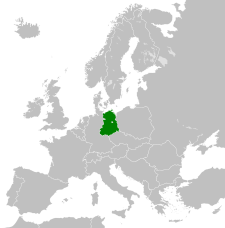
Plaetje:East Germany 1956-1990.svg

Aafmaetinge van dees veurbesjoewing van 't type PNG van dit SVG-bestandj: 450 × 456 pixels Anger resoluties: 237 × 240 pixels | 474 × 480 pixels | 758 × 768 pixels | 1.011 × 1.024 pixels | 2.021 × 2.048 pixels.
Oearsprunkelik bestandj (SVG-bestandj, nominaal 450 × 456 pixels, bestandsgruutde: 474 kB)
Besjrieving


.svg)
.svg)
.svg)
.svg)
.svg)


.svg)
.svg)
.svg)


.png)
.png)


.svg)


.svg)

.svg)


.svg)
.svg)
.svg)
.svg)


.svg)
.png)


.svg)


.svg)
.svg)


.svg)


.svg)


.svg)
.svg)
.svg)
.svg)
.svg)
.svg)
.svg)
_cropped.svg)
.svg)
.svg)
.svg)
.svg)
.svg)
.svg)
.svg)
.svg)
.svg)
.svg)
.svg)
.svg)
.svg)
.svg)
.svg)
.svg)
.svg)
.svg)
.svg)
.svg)
.svg)
.svg)
.svg)
.svg)
.svg)
.svg)
.svg)
.svg)
.svg)
.svg)
.svg)
.svg)
.svg)
.svg)
.svg)
.svg)
.svg)
.svg)
.svg)
.svg)
.svg)
.svg)
.svg)
.svg)
.svg)
| Dit is een geretoucheerde foto, wat betekent dat de originele versie digitaal aangepast is. Het origineel kan hier bekeken worden: Blank map of Europe 1956-1990.svg.
|
Licentie:
Ich, de copyrighthauwer van dit wirk, maak 't hiebie ónger óngerstaonde licentie besjikbaar:
Dit bestandj steit gelicenseerdj óngere Creative Commons Attribution-Share Alike 3.0 Unported lisensje.
- De maags:
- deile – aafsjrieve, verspreie en dórchgaeve
- hèrminge – 't wèrk aanpasje
- Óngere volgendje veurwaerj:
- Attribuusje – Geer mótj op 'n gepasdje meneer 'n naamsvermeljing make, 'ne link nao de licentie opgaeve, en aangaeve of g'r 't werk verangerd höb. Geer moog dit op eder raejelike meneer doon, meh neet zoea det 't liek ofwen de licentiegaever instump mit eur werk of eur gebroek van zie werk.
- Deil gliek – Went geer dit werk geremix, verangerd of doorverwirk höb, mótj geer 't verangerd matterjaal verspreie ónger dezelfde licentie wie 't oersjprunkelik werk, of 'n licentie die daomit samegeit.
Orzjineel uploadlogbook
This image is a derivative work of the following images:
- File:Blank_map_of_Europe_1956-1990.svg licensed with Cc-by-sa-3.0
- 2011-10-30T04:43:42Z Alphathon 450x456 (485146 Bytes) == {{int:filedesc}} == {{Information |Description={{en|Blank map of Europe showing national borders as they stood from 1956-1990.}} |Source=*[[:File:Blank_map_of_Europe.svg|]] |Date=2011-10-30 04:42 (UTC) |Author=*[[:File:Bla
Besjtandshistorie
Klik op 'ne datum/tied óm 't besjtand te zeen wie 't oetzaog op det tiedsjtip.
| Datum/Tied | Miniatuurplaetje | Aafmaetinge | Gebroeker | Kómmentaar | |
|---|---|---|---|---|---|
| hujig | 26 nov 2011 02:33 | | 450 × 456 (474 kB) | StalwartUK | == {{int:filedesc}} == {{Information |Description={{en|Map of the East Germany (German Democratic Republic) as it was from 1949-1990. Surrounding countries accurate from 1956-1990.}} |Source=*[[:File:Blank_map_of_Europe_1956-1990.svg| |
Plaetjesverwiezinge
Dit plaetje weurt op de volgende pazjena's gebroek:
Globaal besjtandjsgebroek
De volgende anger wiki's gebroeke dit bestandj:
- Gebroek in af.wikipedia.org
- Gebroek in am.wikipedia.org
- Gebroek in an.wikipedia.org
- Gebroek in ar.wikipedia.org
- Gebroek in ast.wikipedia.org
- Gebroek in azb.wikipedia.org
- Gebroek in az.wikipedia.org
- Gebroek in ba.wikipedia.org
- Gebroek in be.wikipedia.org
- Gebroek in bs.wikipedia.org
- Gebroek in ca.wikipedia.org
- Gebroek in ce.wikipedia.org
- Gebroek in cs.wikipedia.org
- Gebroek in de.wikipedia.org
- Gebroek in de.wiktionary.org
- Gebroek in diq.wikipedia.org
- Gebroek in el.wikipedia.org
- Gebroek in en.wikipedia.org
- Gebroek in en.wiktionary.org
- Gebroek in eo.wikipedia.org
- Gebroek in es.wikipedia.org
- Gebroek in es.wiktionary.org
- Gebroek in eu.wikipedia.org
- Gebroek in ext.wikipedia.org
- Gebroek in fa.wikipedia.org
- Gebroek in fi.wikipedia.org
- Gebroek in fr.wikipedia.org
- Gebroek in fr.wiktionary.org
- Gebroek in ga.wikipedia.org
- Gebroek in gd.wikipedia.org
- Gebroek in gl.wikipedia.org
- Gebroek in gv.wikipedia.org
- Gebroek in he.wikipedia.org
- Gebroek in hi.wikipedia.org
- Gebroek in hr.wikipedia.org
- Gebroek in hr.wiktionary.org
- Gebroek in hsb.wikipedia.org
- Gebroek in hu.wikipedia.org
- Gebroek in hy.wikipedia.org
- Gebroek in ia.wikipedia.org
- Gebroek in id.wikipedia.org
- Gebroek in is.wikipedia.org
- Gebroek in it.wikipedia.org
Bekiek wikiwied gebroek van dit bestandj.