
Plaetje:California map showing Riverside County.png
Gein hoeger resolutie besjikbaar.
California_map_showing_Riverside_County.png ((200 × 231 pixel, besjtandsgruutde: 22 kB, MIME type: image/png))
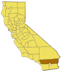
Map of Riverside county in California. From en:

|
Toesteumming wert verleend veur t kopiëre, verspreide en/of wiezige van dit document onger de veurwaerd van de GNU-licentie veur vrieje documentatie, versie 1.2 of einige latere versie es gepubliceerd door de Free Software Foundation; zonger Invariant Sections, zonger Front-Cover Texts, en zonger Back-Cover Texts. n kopie van de licentie is opgenomme in de sectie GNU-licentie veur vrieje documentatie. |
| Dit bestandj steit gelicenseerdj óngere Creative Commons Attribution-Share Alike 3.0 Unported lisensje. | ||
| ||
| Dees licentie-tag woort tougevoeg aon dit bestand in verband mèt de GFDL licentie-update. |
Besjtandshistorie
Klik op 'ne datum/tied óm 't besjtand te zeen wie 't oetzaog op det tiedsjtip.
| Datum/Tied | Miniatuurplaetje | Aafmaetinge | Gebroeker | Kómmentaar | |
|---|---|---|---|---|---|
| hujig | 14 jul 2005 17:23 | | 200 × 231 (22 kB) | Pyramide~commonswiki | Map of Riverside county in California. From en: {{GFDL}} Category:Maps of counties in California |
Plaetjesverwiezinge
Dit plaetje weurt op de volgende pazjena's gebroek:
Globaal besjtandjsgebroek
De volgende anger wiki's gebroeke dit bestandj:
- Gebroek in ar.wikipedia.org
- Gebroek in arz.wikipedia.org
- Gebroek in az.wikipedia.org
- Gebroek in be.wikipedia.org
- Gebroek in bg.wikipedia.org
- Gebroek in ca.wikipedia.org
- Gebroek in ceb.wikipedia.org
- Gebroek in ce.wikipedia.org
- Gebroek in cy.wikipedia.org
- Gebroek in el.wikipedia.org
- Gebroek in en.wikipedia.org
- Low Desert
- Cucamonga Valley
- Little San Bernardino Mountains
- James Reserve
- Salton Sea State Recreation Area
- La Quinta Resort & Club
- Indio Hills Palms
- Cahuilla County, California
- Coxcomb Mountains
- Eagle Mountains
- Pinto Mountains
- Little Maria Mountains
- Mule Mountains (California)
- Mojave and Colorado Deserts Biosphere Reserve
- Hexie Mountains
- San Gorgonio River
- Prado Reservoir
- Template:RiversideCountyCA-geo-stub
- North Palm Springs, California
- Vail Lake
- Reinhardt Canyon
- Midland, California
- Temecula Valley
- Eureka Peak (California)
- Valerie Jean Dates
- Pinyon Pines, California
- Salt Creek (Salton Sea)
- Chino Canyon (California)
- Chino Fault
- Black Hills (Riverside County)
- Cottonwood Mountains (Riverside County)
- Domenigoni Mountains
- Indio Hills
- Jurupa Mountains
- Kalmia Hills
- Little Chuckwalla Mountains
- Pedley Hills
- Rawson Mountains (California)
- Santa Rosa Hills (Riverside County)
- The Badlands (California)
Bekiek wikiwied gebroek van dit bestandj.