
Plaetje:East Timor municipalities numbers 2003-2015.png

Gruutde van dees veurvertuining: 800 × 354 pixels. Anger resoluties: 320 × 141 pixels | 640 × 283 pixels | 1.024 × 453 pixels | 2.000 × 884 pixels.
Oearsprunkelik bestandj ((2.000 × 884 pixel, besjtandsgruutde: 164 kB, MIME type: image/png))
| Besjrieving |
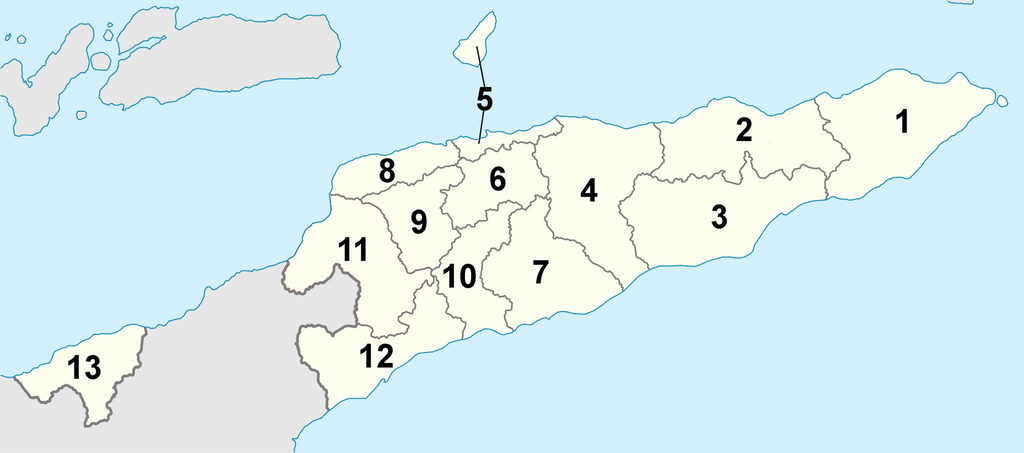
Deutsch: Lagekarte der Gemeinden Osttimors (nummeriert) English: Locator map of municipalities of East Timor (numbered) |
| Datum | (UTC) |
| Brón | |
| Sjriever |
|
| Dit is een geretoucheerde foto, wat betekent dat de originele versie digitaal aangepast is. Aanpassingen: Districts numbered. Het origineel kan hier bekeken worden: East Timor Aileu locator map.svg. Aanpassingen gedaan door J. Patrick Fischer.
|
Ich, de kopierechhaajer hievan, bring 't hiebie óngere vólgendje lisensje oet:
Dit bestandj steit gelicenseerdj óngere Creative Commons Attribution 3.0 Unported lisensje.
- De maags:
- deile – aafsjrieve, verspreie en dórchgaeve
- hèrminge – 't wèrk aanpasje
- Óngere volgendje veurwaerj:
- Attribuusje – Geer mótj op 'n gepasdje meneer 'n naamsvermeljing make, 'ne link nao de licentie opgaeve, en aangaeve of g'r 't werk verangerd höb. Geer moog dit op eder raejelike meneer doon, meh neet zoea det 't liek ofwen de licentiegaever instump mit eur werk of eur gebroek van zie werk.

|
Toesteumming wert verleend veur t kopiëre, verspreide en/of wiezige van dit document onger de veurwaerd van de GNU-licentie veur vrieje documentatie, versie 1.2 of einige latere versie es gepubliceerd door de Free Software Foundation; zonger Invariant Sections, zonger Front-Cover Texts, en zonger Back-Cover Texts. n kopie van de licentie is opgenomme in de sectie GNU-licentie veur vrieje documentatie. |
De kens zelf de lisensje oetkeze.
Orzjineel uploadlogbook
This image is a derivative work of the following images:
- File:East_Timor_Aileu_locator_map.svg licensed with Cc-by-3.0, GFDL
- 2009-05-27T21:09:12Z NordNordWest 1607x710 (127180 Bytes) {{Information |Description= {{de|Lagekarte des Distrikts Aileu, Osttimor}} {{en|Locator map of Aileu district, East Timor}} |Source=self-made, using * [[:file:East Timor location map.svg|East Timor location map.svg]] |Date=2
Uploaded with derivativeFX
Besjtandshistorie
Klik op 'ne datum/tied óm 't besjtand te zeen wie 't oetzaog op det tiedsjtip.
| Datum/Tied | Miniatuurplaetje | Aafmaetinge | Gebroeker | Kómmentaar | |
|---|---|---|---|---|---|
| hujig | 1 jul 2010 08:39 | | 2.000 × 884 (164 kB) | J. Patrick Fischer | {{Information |Description={{de|Lagekarte der Distrikte Osttimors (nummeriert)}} {{en|Locator map of districts of East Timor (numbered)}} |Source=*File:East_Timor_Aileu_locator_map.svg |Date=2010-07-01 06:37 (UTC) |Author=*[[:File:East_Timor_Aileu_ |
Plaetjesverwiezinge
Gein inkel pazjena gebroek dit plaetje.
Globaal besjtandjsgebroek
De volgende anger wiki's gebroeke dit bestandj:
- Gebroek in de.wikipedia.org
- Gebroek in el.wikipedia.org
- Gebroek in en.wikipedia.org
- Gebroek in fa.wikipedia.org
- Gebroek in fr.wikipedia.org
- Gebroek in ko.wikipedia.org
- Gebroek in nl.wikipedia.org
- Gebroek in tet.wikipedia.org
- Gebroek in tr.wikipedia.org
- Gebroek in vi.wikipedia.org
- Gebroek in zh.wikipedia.org